Windy Ridge Viewpoint at Mt St Helens in Washington
Windy Ridge Viewpoint, an alternative to the Johnston Ridge Observatory in Washington state, offers stunning panoramic views of Mt St Helens.
Windy Ridge is only four miles (6.4 km) from Mt St Helens’ crater and is the closest you can get to the volcano without hiking. The viewpoint is on the eastern side of Mt St Helens and is one of the most remote, car-accessible locations in the park.
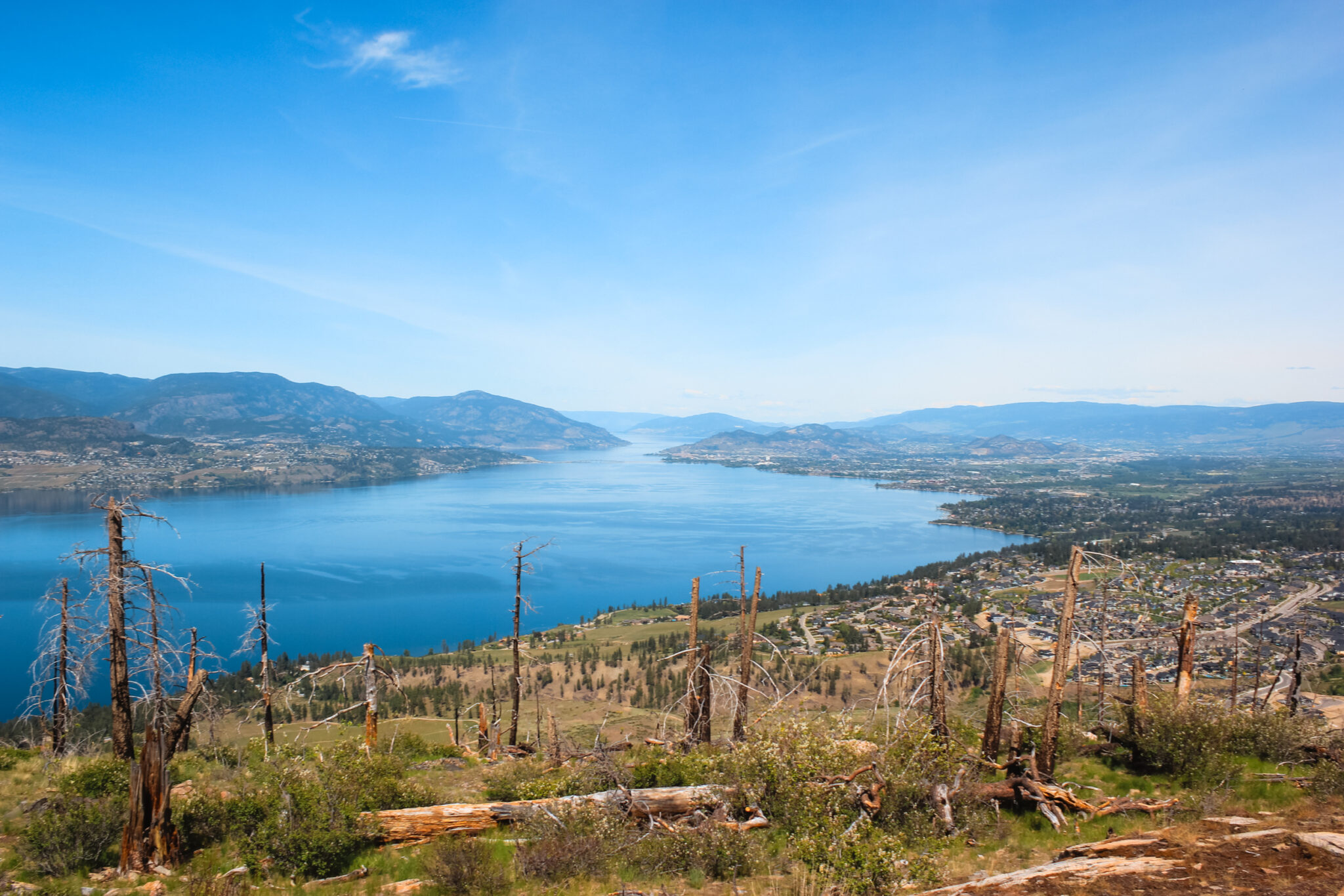
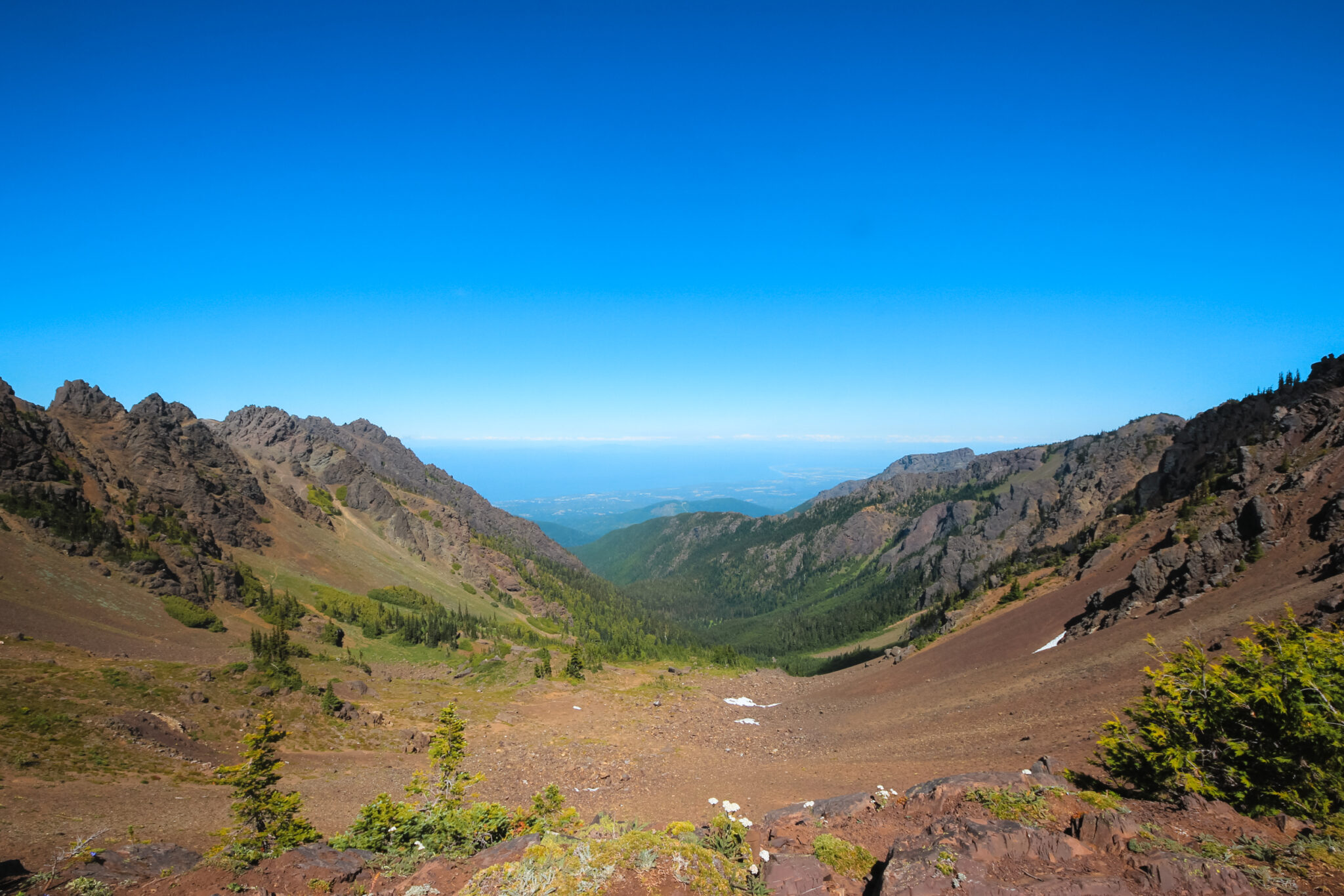
You can see the widespread devastation of Mt St Helens’ 1980 eruption up close. It’s hard to imagine what the area used to look like as you stand amidst the naked hills and toothpick-like trees.
The expansive grey plains are humbling and serve as a stark reminder of the devastation of natural disasters. Yet, you can clearly see life returning. It’s rare to experience firsthand such a sharp contrast between nature’s destructive and restorative powers.
Learn everything you need to know to visit Windy Ridge Viewpoint, including things to do at the viewpoint, nearby attractions, and accommodations near Mt St Helens.

Location Stats
- Difficulty: Moderately easy
- Length: ~0.6 mi / 1 km (see map)
- Elevation gain: 246 ft / 75 m
- Trailhead: Windy Ridge parking lot
- Open Dates: Summer (when roads are snow-free)
- Fee: Northwest Forest Pass
Where is Windy Ridge Viewpoint?
Windy Ridge Viewpoint is located in the Mt St Helens National Volcanic Monument in Washington state.
Windy Ridge Viewpoint is 146 miles (3 hr, 35 mins) from Seattle, 117 miles (3 hr, 6 mins) from Portland, and 86 miles (2 hr, 27 mins) from Mt Rainier National Park.
Despite its remote location inside Gifford Pinchot National Forest, Windy Ridge Viewpoint is easily accessible by car. The entire road is paved and there’s a parking lot (Wakepish Picnic Area) at the bottom where you can drop your trailer before heading up.
Surprisingly, the viewpoint isn’t a popular destination even though it has amazing views of Mt St Helens. Most people visit the Johnston Ridge Observatory on the opposite side of the volcano because it’s more accessible and developed. Luckily, this means you can explore Windy Ridge without huge crowds.
Driving Directions
Windy Ridge is on the eastern slopes of Mt St Helens in Gifford Pinchot National Forest. The roads here are windy, narrow, and riddled with potholes. The thick forest creates a dappled light which makes these hazards difficult to see.
Expect your drive to take longer than what Google says.
Directions from Seattle
There are many ways to drive the 149 miles (240 km) from Seattle to Windy Ridge Viewpoint. You could even add an hour and detour through Mt Rainier National Park!
From Seattle, head south on Highway 5 to Tacoma. If you want to avoid the middle of the two cities, there are plenty of smaller highways and roads you can take instead.
Next, take Highway 7 south until you reach Morton. Highway 7 ends here, so turn left onto Highway 12 East with signs for White Pass and Yakima. Stay on Highway 12 for 17 miles until you reach Randle.
In Randle, turn south onto Highway 131 which turns into NFD-25. Stay on NFD-25 for 17 miles, then turn right onto NF-99 (with signs for Windy Ridge). Continue for 16 miles until you reach the viewpoint and the end of the road.
Tip: When putting Windy Ridge into your GPS or Google, double-check the route. Sometimes it will try to bring you on random service roads. I suggest adding Randle and Iron Creek Falls as waypoints to ensure you get the correct route.
Directions from Portland
Windy Ridge Viewpoint is 118 miles (190 km) from Portland. From Portland, head north on Highway 5 to Woodland. In Woodland, take Exit 21 onto Highway 503 East with signs for Cougar.
You’ll stay on this road for 72 miles until you reach the turn-off for Windy Ridge. However, the road changes names a few times. Highway 503 turns into NF-90 in Cougar. Then, just after the Swift Forest Camp, NF-90 turns into NFD-25.
Finally, turn left onto NF-99 (with signs for Windy Ridge). Continue for 16 miles until you reach the viewpoint and the end of the road.
Tip: When putting Windy Ridge into your GPS or Google, double-check the route. Sometimes it will try to bring you on random service roads. I suggest adding Randle and Iron Creek Falls as waypoints to ensure you get the correct route.
Directions from Johnston Ridge Observatory
Even though Windy Ridge Viewpoint and the Johnston Ridge Observatory are geographically close, it takes 3 to 4 hours to drive between the two. There aren’t a lot of roads around Mt St Helens, which means you have to backtrack and take a huge round-about route via either Highway 12 (north) or Highway 503 (south).
Unless you’re seeing other things along the way, it’s probably not worth taking this huge detour just to see both viewpoints.
You could, however, hike from Windy Ridge to the Johnston Ridge Observatory. See the Truman Trail below for more details.
North Route via Highway 12
South Route via Highway 503
Driving Notes
Regardless of which direction you come, once you turn onto NF-99, drive for 16 miles (25.7 km) until the road ends. The drive takes about 45 minutes (or longer if you stop at the various viewpoints) and brings you through a spectacular showcase of Mt St Helens’ power. The road is paved, but it’s windy and in disrepair. Spots of the road are missing and there are gravel patches.
As you drive up, you’ll enjoy sweeping views of the recovering valleys and Mt St Helens will occasionally peek her head from behind the mountains. Hundreds of thousands of trees look like they’ve been blown over by angry giants. There are many pull-offs along the way that offer great views and hikes, it would be easy to spend your entire day exploring. Always drive with caution because the area is full of wildlife and steep drop-offs.
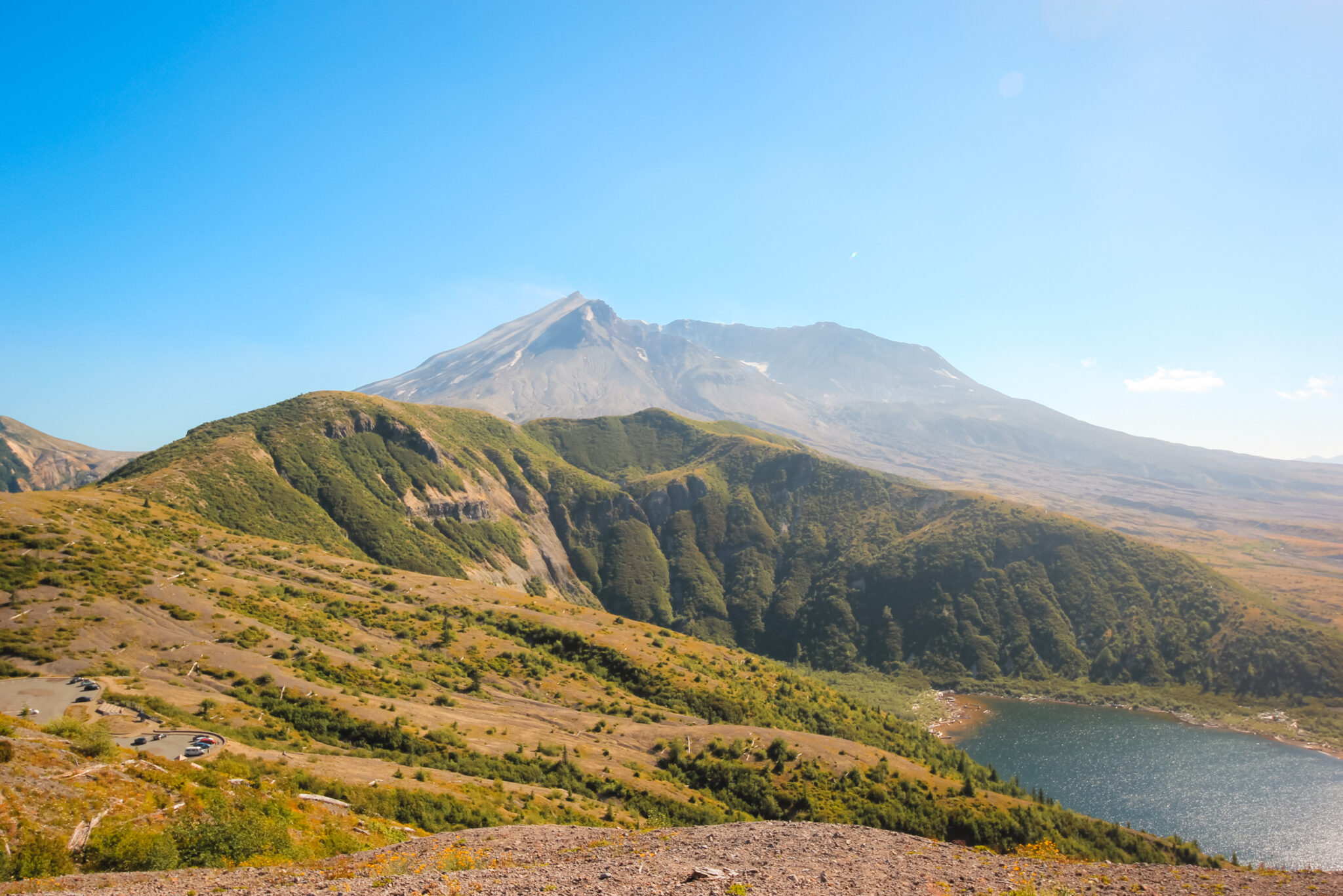
When you reach the Windy Ridge parking lot at the end of the road, you’ll see Mt St Helens rise majestically in the background. She towers over everything and small smoke clouds hover above her slowly growing lava dome. Mt St Helens’ slopes are bathed in green and a young glacier peeks out from her crater. This lonely viewpoint is certainly worth the drive!
Windy Ridge is inaccessible in the winter because the roads (NFD-25 and NF-99) are closed due to snow.
Know Before You Go
Windy Ridge Viewpoint is a great, family-friendly destination where you can enjoy wonderful views of Mt St Helens without straining yourself. There’s no strenuous hiking involved, other than climbing the awkward sand ladder.
Before you head up, there are a few important things to know, such as fees, open dates, and access roads.
Fees for Windy Ridge
Technically, Windy Ridge is free to visit, but you need a Northwest Forest Pass to park. The Northwest Forest Pass is $5 a day or $30 annually. So unless you plan on driving up and not even getting outta your car, there’s a small fee for visiting.
You can either buy the pass locally, order it online ahead of time (it will be mailed to you), or print a National Forest Recreation ePass. If you can, it’s easiest to buy the pass online so that you’re not worried about finding a local vendor.
Always display the pass in your front window when you leave your car otherwise you could be in for a hefty fine. The Northwest Forest Pass is valid for all parking at Mt St Helens and all other national forests in Washington and Oregon. If you’re planning on travelling around, the annual pass pays for itself quite quickly.
Open Dates for Windy Ridge
Windy Ridge Viewpoint is only open during the summer and is accessible 24 hours a day during that time. In the winter, the road is closed because of snow.
The road to Windy Ridge Viewpoint usually opens in late June or July, depending on the snow levels.
NFD-25 & NF-99
The two roads to Windy Ridge, NFD-25 and NF-99, are both paved but in rough condition. There are often potholes and recently there have been reports of missing sections and gravel patches.
The roads are also extremely windy, so you need to be careful and drive slowly. All in all, though, you can easily drive almost any vehicle (except large motorhomes or RVs) to the viewpoint. Please drop your trailers at the parking lot at the beginning of NF-99.
Facilities & Amenities at Windy Ridge Viewpoint
Windy Ridge is smaller and more remote than the ever-popular Johnson Ridge Observatory, which means there are fewer amenities and facilities here. However, that doesn’t mean you’re left without anything!
Toilets
There’s a washroom at the base of the Windy Ridge sand ladder. It’s a surprisingly nice building with pit toilets inside, no gross blue outhouses here!
Amphitheatre
Free ranger talks are given at the Windy Ridge amphitheatre every hour on the half-hour during the summer. The amphitheatre is located just below the parking lot and overlooks Mt St Helens. This is a great way to learn more about Mt St Helens!
Large Parking Lot
There’s a large parking lot at Windy Ridge Viewpoint with room for about a hundred cars and four dedicated spaces for RVs or buses. The parking lot almost never fills, so you should have no trouble getting a parking spot,
The road to the viewpoint is quite windy and narrow, though, so I don’t recommend bringing your RV or trailer up. Luckily, there’s a parking lot (Wakepish Picnic Area) at the bottom of NF-99 where you can leave your trailer.
Educational Signs
There are plenty of educational signs throughout the viewpoint. If you’re unable to attend a ranger talk at the amphitheatre, you can still learn a lot about Mt St Helens and Spirit Lake from these signs.
Things to Do at Windy Ridge Viewpoint
The main attraction at the Windy Ridge viewpoint is its unbelievable 360° view of Mt St Helens. However, there’s more to do here than gaze at the volcano!
Windy Ridge Hiking Trail
Don’t miss out on the stunning views! Sure, the views from the Windy Ridge parking lot are a million times better than most parking lots, but the best views are only accessible by climbing the nearby 368-step sand ladder.
The Windy Ridge sand ladder, which is basically a staircase, is located just off the parking lot. You can’t miss it. The staircase makes the amazing views easily accessible, although it’s a tiring climb. The steps are mostly pumice gravel and the large stride makes the trail awkward. There are no trees on the hill, so you’ll be exposed to the wind and sun the entire time.
At the top, you have an unobstructed 360° view of Mt St Helens and the huge, decimated plains. The sheer distance you can see is astounding. To the north, the log-filled waters of Spirit Lake are easily seen. If it’s a clear day, Mt Rainier, Mt Adams, and even Mt Hood rise from the skyline around you. If you’re lucky, you’ll be able to see four volcanoes from Windy Ridge Viewpoint!
A short walk from the top of the ladder brings you to a wooden observation platform with information about Mt St Helens and Spirit Lake. For most people, this is as far along the Windy Ridge Trail as they’ll hike. All in all, it’s about 0.6 miles.
However, you can continue on. The full Windy Ridge Trail is 2.2 miles long and ends at a small parking lot at the Upper Smith Creek Trailhead (which is on the main road).
Other Hiking Trails Near Windy Ridge
There are numerous hiking trails near Windy Ridge Viewpoint that range in difficulty and length. In fact, the hiking trails at Mt St Helens are extensive and you could easily spend weeks exploring them all.
The following are some of the more well-known Mt St Helens hiking trails that connect with Windy Ridge, but you could easily create your own routes because many of the trails connect with one another (but don’t hike off-trail, the ecosystem is fragile).
Meta Lake Trail | 0.6 mi, Easy
The Meta Lake Trail is a short hiking trail located at a viewpoint on NF-99 (the road that leads to Windy Ridge). Sometimes, the water level at Meta Lake floods the trail. It’s basically flat, with only 16 feet of elevation gain. You can also hike to Miner’s Car Interpretive Site from here.
Harmony Trail | 2.5 mi, Moderate
The Harmony Trail is the only way to access Spirit Lake. The first half of the trail is shaded, but the second half is quite exposed. The hike back from Spirit Lake is entirely uphill with 614 feet of elevation gain.
Loowit Falls Trail | 8 mi, Moderate
Loowit Falls Trail begins at the Windy Ridge parking lot. Most of the trail is quite exposed which offers amazing views of Mt St Helens and even a few waterfalls! It has 1,171 feet of elevation gain.
Plains of Abraham Loop | 8.4 mi, Moderate
The Plains of Abraham Loop begins at Windy Ridge Viewpoint. It has 1,411 feet of elevation gain and brings you through the Pumice Plains around Mt St Helens.
Strawberry Mountain Trail | 8.4 mi, Moderate
Unlike trails on Pumice Plains, this trail has plenty of forest cover. You can enjoy delicious wild strawberries and views of Mt St Helens, Mt Adams, and Mt Hood. Once you’ve made it to the top of the mountain, the trail becomes fairly flat. There’s a total of 2,454 feet of elevation gain.
Truman Trail | 14 mi, Moderate
The Truman Trail at Mt St Helens follows Spirit Lake (from a distance) and heads towards Johnston Ridge Observatory (you could continue on to it). It has 1,959 feet of elevation gain.
Smith Creek Trail | 20 mi, Difficult
The Smith Creek Trail begins on the Windy Ridge Trail, then follows Smith Creek and doubles back. Except for the very beginning and end (where most of the 4,177 feet of elevation gain occurs), this hike is pretty flat.
Mt St Helens Loop Trail | 33 mi, Difficult
This multi-day backpacking hike loops around the entirety of Mt St Helens. It has 5,538 feet of elevation gain.
Spirit Lake Viewpoint
Spirit Lake is only five miles north of Mt St Helens. It was once a popular vacationing spot and had six camps on its shores. People flocked to its crystal clear waters and serene beauty. But when Mt St Helens erupted in 1980, everything changed.
Today, you can see Spirit Lake from Windy Ridge. At the top of the sand ladder, there’s a wooden observation platform where you can learn about Spirit Lake and see the log mat that still covers some of the lake.
The only public access to Spirit Lake is via the Harmony Falls Trail on its northeastern shore.
History of Spirit Lake
When Mt St Helens erupted, Spirit Lake received the full force of the blast. The eruption triggered a gigantic avalanche that slammed into the lake and forced the water 600 feet up its northern banks. When the water finally settled, Spirit Lake was irreversibly changed.
Spirit Lake was suddenly 200 feet higher, filled with volcanic debris, and the vacationing spots were long gone. Hundreds of thousands of trees floated in the water and created a dense log mat that covered over 40% of the lake’s surface. Because of this, the 4,000-year-old lake would never be the same.
Even though Spirit Lake is no longer a vacation spot, it has a new purpose as a hotbed for scientific discovery. Within a year of the eruption, scientists were amazed to see that life was already returning to the lake! There’s limited public access so that researchers can preserve the natural laboratory and gather long-term data.
Ranger Talk at Windy Ridge
If you’re interested in learning more about Mt St Helens, be sure to attend the Ranger Talk at the amphitheatre. There isn’t a Visitor Centre at Windy Ridge Viewpoint, so this is a great way to learn more about the area. The amphitheatre is located just off the parking lot and overlooks Mt St Helens.
The talks are free and are given every hour on the half-hour.
More Nearby Things to Do
After you’ve explored Windy Ridge to your heart’s content, there are plenty of other things to do on the eastern side of Mt St Helens.
Iron Creek Falls | 0.2 mi, Easy
Iron Creek Falls is a short, easy 0.2 mi trail to a beautiful waterfall and ice-cold swimming hole near the turn-off for NF-99. Don’t miss this stunning waterfall located off the side of the road! Iron Creek Falls is 16.4 mi from Windy Ridge.
Curly Creek Falls | 0.8 mi, Easy
Take a short, easy 0.8 mi hike to Curly Creek Falls. This waterfall is best during the spring or early summer when there’s plenty of water.
Unfortunately, you can’t get too close to the falls, but it’s still fun to check out. Curly Creek Falls is 47 mi from Windy Ridge.
Ape Cave Lava Tubes | Various Lengths & Difficulties
Want to take a hike to the centre of the earth? Or least into the lava tubes of the most active volcano in the Cascade Range?
Despite sounding super sketchy, Ape Cave is actually an incredibly fun and safe-ish underground adventure at Mt St Helens.
Ape Cave is 56.4 mi from Windy Ridge.
Lava Canyon Hike | Various Lengths + Difficulties
Hike through the beautiful two-thousand-year-old volcanic landscape around Mt St Helens, make your way over an impressive suspension bridge, and enjoy a gorgeous waterfall and river.
This hike has varying levels of difficulty, so you can choose how long and/or hard to make your hike.
Lava Canyon is 65 mi from Windy Ridge.
The History of Windy Ridge
Windy Ridge offers unbelievable views of Mt St Helens’ blast zone. When the volcano erupted, it triggered a massive avalanche that destroyed almost everything within view. The barren land to the north of Mt St Helens’ crater is now called Pumice Plains and is made of the hardened debris from that avalanche.
When Mt St Helens erupted, it blasted the plains with pumice and gases that reached almost 1,200 °F (649 °C)! Needless to say, it killed everything that wasn’t able to escape. Today, scientists are amazed with how many plants have grown back!
Building Windy Ridge Viewpoint
People come to Windy Ridge for its amazing views of Mt St Helens and Pumice Plains, but those views didn’t exist before 1980.
Prior to 1980, there were some hikes and a few camps around Mt St Helens, but they all disappeared in the blink of an eye when the volcano erupted. In the aftermath, park planners suddenly had a clean slate to create viewpoints and trails with the sole purpose of allowing people to experience Mt St Helens’ unique features. One of the viewpoints they created was Windy Ridge.
Amazingly, Windy Ridge Viewpoint was built within just a few years. Considering the amount of work that was needed to clear the decimated mountain, it’s impressive how quickly the park builders were able to complete the viewpoint. Only a few short years after the eruption, people were already visiting Windy Ridge to experience Mt St Helens’ destructive power.
Mt St Helens’ Recovering Ecosystem
After the initial shock of seeing the aftermath of Mt St Helens’ eruption, you’ll notice that life is returning. The plants are flourishing and everything from small foliage to large saplings are overtaking the area. It’s pretty cool to see the ecosystem repair itself.
I’ve visited Mt St Helens multiple times over the years; first in 2004, then in 2010, and most recently in 2016. Each time, the obvious ecological change astounds me.
When I first visited in 2004, there was very little plant life and the dead trees stood stark against the mountainside. Twelve years later, I was amazed by the sheer amount of green everywhere. The startling toothpick-like trees I remembered from childhood were engulfed by new life. Nature’s ability to restore herself is truly beautiful and I’ve never seen it on such display as at Mt St Helens.
Where to Stay near Windy Ridge
If you’re planning on exploring the eastern side of Mt St Helens, there are plenty of places where you can stay overnight.
Keep in mind that Windy Ridge is remote, which means you’ll still need to drive for at least an hour even if you do stay in the area.
Camping on the Eastern Side of Mt St Helens
The following campgrounds are a mixture of front-country, RV parks, dispersed, and backcountry campsites. Please look into each campground to see if it meets your needs before deciding that’s where you’ll stay. Some of the sites are quite remote with few (if any) amenities.
- Beaver Bay Campground
- Climber’s Bivouac Campground
- Cougar RV Park & Campground
- Cresap Bay Park
- Cultus Creek Campground
- Dome Camp
- Eagle Cliff Park
- Green River Horse Camp
- Iron Creek Campground
- Kalama Horse Camp Campground
- Lewis River Horse Camp
- Lower Falls Campground
- Marble Mountain Snopark
- Merrill Lake Campground
- Pinchot National Forest
- Pumice Butte
- Saddle Dam Campground
- Swift Forest Camp
- Twin Falls Campground
- Wakepish Sno-Park
Hipcamp
Hipcamp is basically the Airbnb/VRBO of camping. You can find some really unique places to camp with Hipcamp. Here’s $10 for your first stay with Hipcamp!
Hotels & Resorts near Cougar, Washington
There aren’t a lot of hotels or resorts near Windy Ridge, but you do have some options if you didn’t feel like camping!
VRBO near Mt St Helens
If you haven’t heard of VRBO before, it’s very similar to Airbnb. And luckily, there are plenty of VRBO’s available near Mt St Helens (even full houses)!
FAQs at Windy Ridge
The sand ladder staircase at Windy Ridge Viewpoint has 368 steps. These steps are made of pumice gravel and are wide and awkward.
Windy Ridge is located on the eastern side of Mt St Helens in Washington state. It’s in the Cascade Mountains near Seattle and Portland.
You can drive within 4 miles of Mt St Helens by visiting the Windy Ridge Viewpoint. This is the closest you can drive to the volcano.
Even though Spirit Lake was changed forever when Mt St Helens erupted, it’s certainly not gone! It’s no longer a vacationing spot, but you can walk down to it on the Harmony Falls trail.
No, you cannot fish in Spirit Lake. Before Mt St Helens erupted in 1980, it was a popular fishing spot, but now Spirit Lake is a unique natural research lab and fishing is no longer permitted.
Gear Recommendations
Even though you’ll probably only spend a short time exploring Windy Ridge Viewpoint, there are a few things you should consider packing.
As the name suggests, it’s very windy at Windy Ridge! When the wind’s strong, it can also get a little chilly, so don’t be afraid to dress warmly even if it’s a sunny summer’s day (a windbreaker or lightweight jacket should be enough). However, there are no trees so you’ll definitely need a pair of sunglasses and sunscreen. It’s a weird mix of gear!