Christie Falls Hiking Trail in West Kelowna, BC
Christie Falls is a stunning, free-falling waterfall located near Kelowna, BC.
The waterfall is an Okanagan gem and is well worth the hour-long drive on a bumpy service road. You’ll hike through a forest of charred trees, scramble over fallen trees, navigate small stream crossings, and make your way down a steep, difficult trail before coming to the gorgeous waterfall.
The hike itself is quite short, but it’s much more than a gentle walk through the woods. It’s a wonderful day adventure with its fair share of challenges. You will lose service, so always let someone know where you’re headed and when they can expect you back.
Read next: The Best Waterfalls in Kelowna & the Okanagan »

Trail Stats
Christie Falls is a beloved local Okanagan waterfall, but due to its remote location, you likely won’t encounter many people on the trail. I was lucky enough to have the waterfall all to myself!
- Difficulty: Moderate
- Trail Type: Out-and-back
- Length: 2.4 km (see map)
- Elevation gain: 105 m
- Trailhead: Christie Falls parking lot
- Open Dates: mid-May to early fall
- Fee: Free
What to Expect at Christie Falls
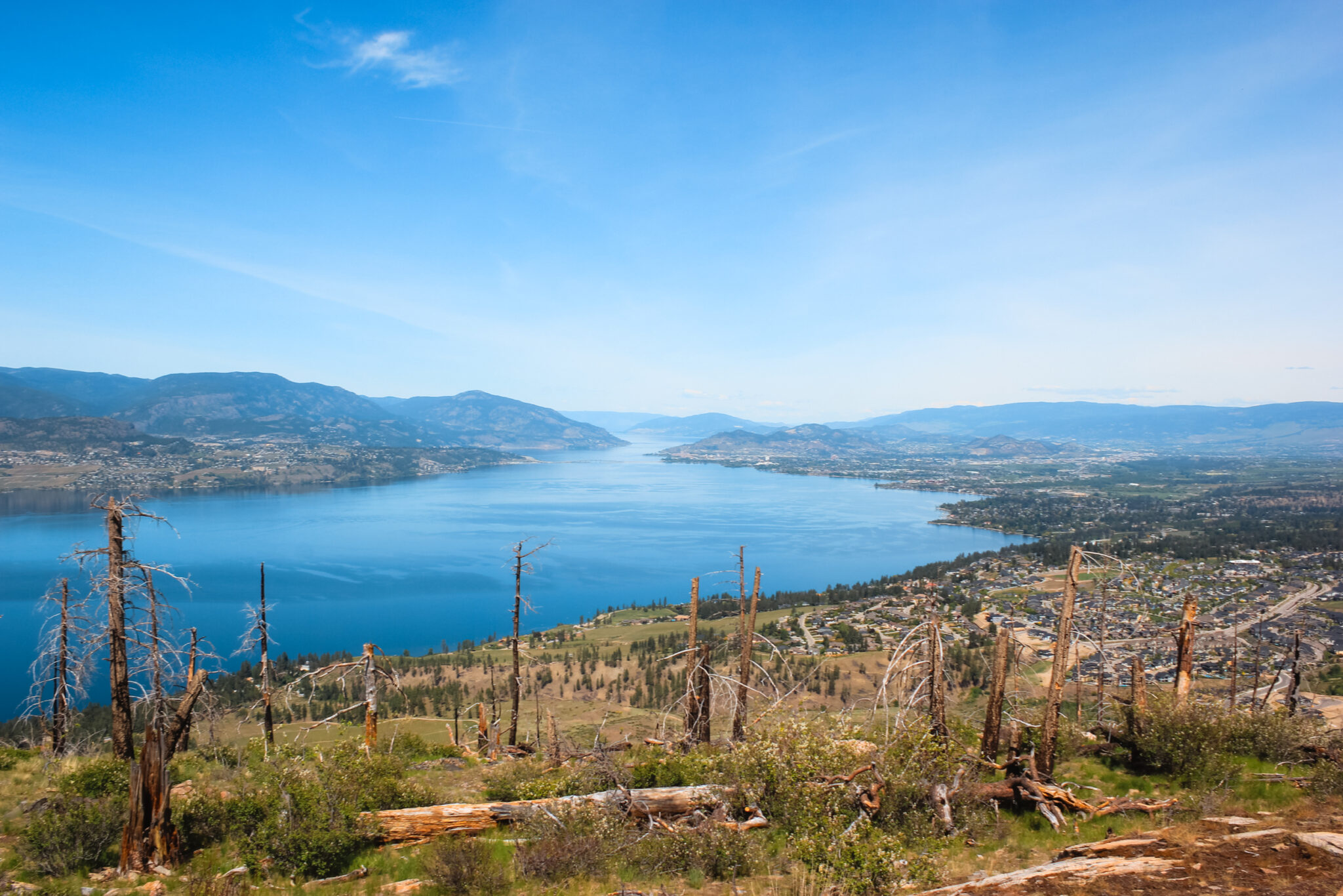
Christie Falls is a hidden gem, nestled in the mountains northwest of Kelowna just behind Bear Creek Provincial Park. The waterfall is located on the backside of Terrace Mountain and overlooks the Fintry Protected Area.
When to Visit Christie Falls
Christie Falls is located high in the mountains (about 1300m) which means snow stays quite late into the year and can make the road impassable. Mid-May to June is the earliest you should try to access the trail.
Jacob and I once tried to access it in late April and we were met with a pile of snow long before we came to the trailhead. Remember, just because it’s hot in the valley doesn’t mean the snow’s gone from the mountains.
Directions to Christie Falls
To reach the Christie Falls trailhead, you’ll need to drive for 28 km up a washboardy, pothole-riddled forestry road. Even though it’s only 28 km, the drive is slow and takes about an hour.
We took my sister’s 4Runner instead of my Escape because I was worried about the rough road. However, other people didn’t seem to have the same worries and we spotted small cars and even a travel van on the bumpy roads. Even after seeing that, I would still only recommend a sturdy SUV or truck — the roads can get pretty rough.
It can be daunting to head up into the mountains on a forestry road, but luckily Google will lead you to the trailhead without any problems. Google Maps works without service, so as long as you’ve preloaded the directions you’ll easily navigate your way through the mountains. We also used a Garmin GPS which recorded our progress.
Despite the rough road, it’s an absolutely gorgeous drive. You leave behind civilization quite quickly and can instead enjoy views of the sprawling forest and colourful wildflowers. There are a few small lakes along the way and the largest is the Big Horn Lake Dam. It’s a pretty lake even if it does look very man-made. There’s even a small campsite on the lake, as well as a few others along the drive up.
Navigating an FSR
Christie Falls is located up a series of logging roads, which means it’s important to know where you’re going so you don’t get lost. I recommend loading up Google Maps before you head out — it led us straight to the trailhead with no issues.
- From Kelowna, drive towards West Kelowna and over the bridge.
- Turn right onto Westside Road at the first overpass (with signs for Bear Creek Provincial Park and Fintry).
- Continue 8.4 km and then turn left onto Bear Lake Main Road (just past Bear Creek).
- Stay on Bear Lake Main for 12 km, then take a right at the large fork.
- Continue for 10.7 km until you reached the far side of Big Horn Lake, then turn right onto Terrace Mountain Road.
- Drive for 3.6 km, then turn left onto a road marked with a small “Christie Falls” sign (at about the 27 km logging marker – if see the 28th, you’ve gone too far).
- Stay on this road for 2.5 km until you come to the parking lot and trailhead.
Parking for Christie Falls
There’s a large dirt parking lot at the Christie Falls trailhead. If the road leading up to it is washed out or looks a little too sketchy to drive up, you can park along the road below. Just be sure to pull off to the side.
Christie Falls Trailhead
After an hour of driving, you’ll finally reach the Christie Falls’ trailhead. The parking lot is quite large and has plenty of room for all kinds of vehicles.
We parked on the road about 100 m before the parking lot because the final hill was incredibly washed out. Much to our surprise, the travel van we’d encountered earlier braved the hill and, to be honest, I’m very surprised they made it.
There aren’t any signs at the trailhead, but it’s clear where to begin. The trail is a 2.9 km there-and-back hike with moderate and difficult sections. You’re in for a real treat of an adventure! Having said that, I don’t recommend the hike for young kids because there are some technically difficult sections near the end.
Part 1: Moderate Hike
The Christie Falls hike begins as a gentle, fairly easy walk through the forest and for the most part, you’ll head steadily downhill. The area was affected by the Terrace Mountain fire in 2009 and you’ll meander through evidence of this fire. There are thousands of charred trees, but there’s also beautiful new green growth and wildflowers pushing their way through the forest floor.
Before long, the trail becomes a more difficult. You’ll climb over or under fallen trees. Some of them are quite charred and if you’re not careful, you’ll get covered in ash. You’ll also have to cross Christie Creek, the small creek that feeds the waterfall. Logs create a bridge across the water. We scooted across the first time, then ended up walking across on the return trip. Be careful!
After crossing the water, the trail heads uphill and you’ll soon reach the edge of the canyon. From here, the hike to the waterfall gets a lot more difficult. If you’re uncomfortable going down the steep trail and using ropes, you can view Christie Falls from above by continuing along the trail. Be very careful, though, and don’t get too close to the edge. It’s a long way down.
Part 2: Difficult Descent
The final section of the hike to Christie Falls involves ropes and a very steep descent.
The steep descent begins immediately after leaving the trail at the top of the canyon. You’re basically heading straight down the side of the mountainside.
The ropes are no joke and you’ll need to use them. In fact, the entire trail from when you start the descent to when you reach the waterfall has ropes. It’s only about a half kilometer round trip, but don’t underestimate the difficulty or awkwardness of this section of the trail.
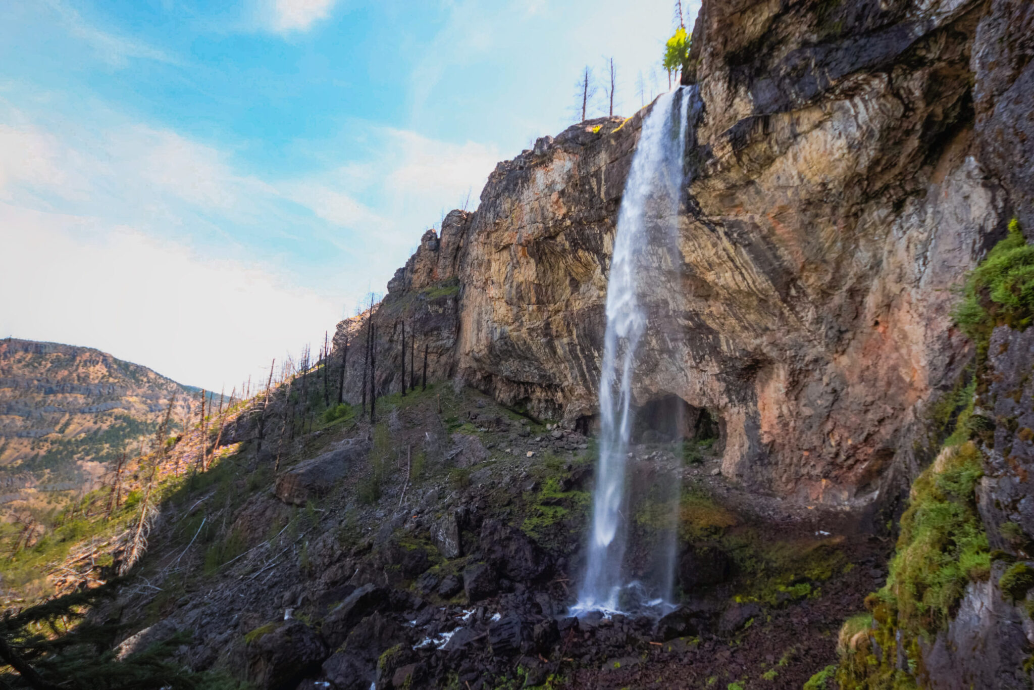
You won’t see the waterfall from the trail until you round the last corner — this is also where the ropes end. But when you round that final corner? Wow! Christie Falls is absolutely stunning.
Exploring Christie Falls
Christie Falls is located within a small, almost cave-like gorge within the mountainside. Christie Creek falls lazily from hundreds of feet above, before quickly plummeting into a free fall into the sharp rocks far below. It’s a unique waterfall within the Okanagan because the water doesn’t simply fall down the mountainside and you can walk around the entire waterfall.
When you first come upon the waterfall, the hill is covered in loose rocks. Depending on the time of year you visit, there may even be snow tucked into some of the shaded crevices. You’ll be sprayed with water from the falls, but unlike some waterfalls within the Okanagan, you’ll be able to breathe easily the entire time.
As you explore behind the falls, the ground becomes easier to walk on and you’ll come to a small landing where you could enjoy a picnic. A small cave and large tree are located here as well. The rope swing is located between the entrance to the waterfall and the landing.
It was about noon when I finally made it to the waterfall, but the entire area was still shaded. It’s a great place to cool off on a hot summer’s day!
Rope Swing at Christie Falls
Christie Falls is well-known for the rope swing at the base of the waterfall. I’ll admit that photos of people swinging gracefully over the beautiful falls were a huge reason I wanted to check out the waterfall for myself. There’s something magical about rope swings in nature.
However, once I started thinking about it and actually saw the rope swing, I decided I didn’t want to try it. The rope is left up year-round and is attached to the rocks near the top of the falls, which means you can’t see its condition before you use it. Maybe it’s just me, but I want to make sure the rope I’m putting my safety into is in good condition. Plus, the rope swings out over a steep gulch with many sharp rocks at the bottom.
Many people have used the swing without incident, but some haven’t been as lucky. In 2018, a man was helicoptered out by Search and Rescue after falling from the rope swing. I’m not trying to scare you, but I do want you to know the situation you’re putting yourself into if you choose to use the swing.
Gear Recommendations
- Ten hiking essentials: Christie Falls is remote, so it’s important to be prepared in case you’re injured or are forced to spend the night in the mountains. Make sure you bring the ten hiking essentials.
- Hiking boots: Christie Falls is no place for flip flops. Make sure you wear heavier duty boots, such as the KEEN Oshawa waterproof boot.
- Wool socks: Wool socks provide great cushioning, wicking, and temperature control for your feet. I love Darn Tough’s socks.
- Hiking day pack: Even though it’s a short hike, a day pack will allow you to easily store all of your gear. The Deuter Race Air 10L Backpack is similar to my backpack.
- Skin protection: It’s important to protect your skin, so remember to pack sunscreen, sunglasses, and a brimmed hat. Consider bringing bug spray as well, although I didn’t have any trouble with bugs.
- Water reservoir: I love water reservoirs. They’re an easy way to carry lots of water and to actually stay hydrated. I have the HydraPak 3L reservoir and I love it!